We have tested the performance of the Plateau de Bure antennas by doing repeated pointing measurements on strong sources. The measurement technique was either cross scans of about 30 seconds duration, or five point maps with 10 second integrations on each of the five points. After each measurement the pointing corrections were updated. Focusing was also done on the same sources.
The sources were 2230+114, 3C454.3, 0923+392; their fluxes were in the
range 4 to 6 Jy. The ![]() measurement errors were
0.12-0.20'' for the five point method and 0.25-0.50'' for the
cross scan method. The results are summarised in
Table 3. Only four antennas were available. The
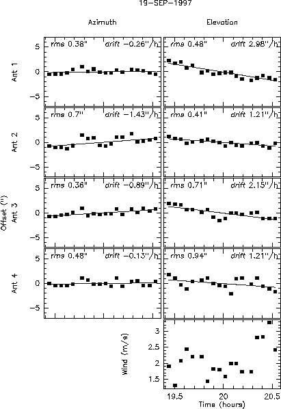
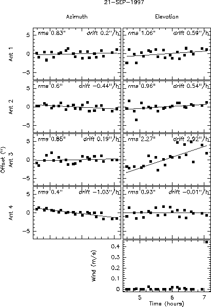
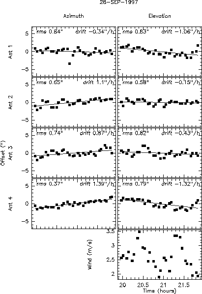
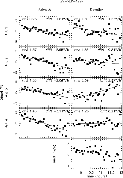
measured pointing errors show a slow drift (a few seconds per hour),
and short term fluctuations. The results are shown in
Figs. 1 to 5. For each day I have computed
the residual r.m.s. deviation after removing a polynomial baseline
(linear for the short experiments, of degree 2-4 for the long ones).
measurement errors were
0.12-0.20'' for the five point method and 0.25-0.50'' for the
cross scan method. The results are summarised in
Table 3. Only four antennas were available. The
measured pointing errors show a slow drift (a few seconds per hour),
and short term fluctuations. The results are shown in
Figs. 1 to 5. For each day I have computed
the residual r.m.s. deviation after removing a polynomial baseline
(linear for the short experiments, of degree 2-4 for the long ones).
| 19 Sep. | Wind: 2.1 m/s Elevation | |||||||
| night | Seeing(Az) .31 Seeing(El) .40 | |||||||
| Axis | Azimuth | Elevation | ||||||
| Antenna | 1 | 2 | 4 | 5 | 1 | 2 | 4 | 5 |
| Pointing rms | .38 | .70 | .36 | .48 | .48 | .41 | .71 | .94 |
| Tracking rms | .57 | .37 | .33 | .76 | .35 | .23 | .27 | .18 |
| Measurement rms | .52 | .44 | .20 | .26 | .38 | .23 | .23 | .24 |
| 20 Sep. | Wind: 4.5 m/s Elevation | |||||||
| noon | Seeing(Az) 2.90 Seeing(El) 3.56 | |||||||
| Axis | Azimuth | Elevation | ||||||
| Antenna | 1 | 2 | 4 | 5 | 1 | 2 | 4 | 5 |
| Pointing rms | 2.13 | 1.43 | 2.42 | 1.64 | 2.71 | 3.35 | 3.89 | 3.17 |
| Tracking rms | .36 | .25 | .25 | .46 | .35 | .29 | .31 | .25 |
| Measurement rms | 1.18 | 1.01 | 1.02 | .98 | .98 | .95 | .94 | .98 |
| 21 Sep. | Wind: .0 m/s Elevation | |||||||
| sunrise | Seeing(Az) .69 Seeing(El) .71 | |||||||
| Axis | Azimuth | Elevation | ||||||
| Antenna | 1 | 2 | 4 | 5 | 1 | 2 | 4 | 5 |
| Pointing rms | .83 | .60 | .85 | .40 | 1.06 | .96 | 2.27 | .93 |
| Tracking rms | .38 | .27 | .27 | .39 | .39 | .28 | .30 | .29 |
| Measurement rms | .53 | .46 | .23 | .22 | .36 | .30 | .29 | .42 |
| 21 Sep. | Wind: .0 m/s Elevation | |||||||
| day | Seeing(Az) 3.21 Seeing(El) 4.23 | |||||||
| Axis | Azimuth | Elevation | ||||||
| Antenna | 1 | 2 | 4 | 5 | 1 | 2 | 4 | 5 |
| Pointing rms | 2.61 | 2.12 | 2.76 | 2.46 | 3.11 | 2.94 | 2.80 | 3.14 |
| Tracking rms | .38 | .27 | .27 | .39 | .39 | .28 | .30 | .29 |
| Measurement rms | .73 | .70 | .54 | .58 | .61 | .52 | .55 | .60 |
| 25 Sep. | Wind: 2.0 m/s Elevation | |||||||
| day | Seeing(Az) .69 Seeing(El) 1.01 | |||||||
| Axis | Azimuth | Elevation | ||||||
| Antenna | 1 | 2 | 4 | 5 | 1 | 2 | 4 | 5 |
| Pointing rms | .51 | .65 | .94 | .34 | 1.40 | 1.00 | 1.29 | 1.05 |
| Tracking rms | .47 | .58 | .26 | .67 | .20 | .13 | .23 | .18 |
| Measurement rms | .12 | .12 | .12 | .12 | .12 | .12 | .13 | .12 |
| 28 Sep. | Wind: 2.5 m/s Elevation | |||||||
| night | Seeing(Az) .59 Seeing(El) .69 | |||||||
| Axis | Azimuth | Elevation | ||||||
| Antenna | 1 | 2 | 4 | 5 | 1 | 2 | 4 | 5 |
| Pointing rms | .84 | .65 | .74 | .37 | .83 | .58 | .82 | .79 |
| Tracking rms | 2.67 | .49 | .29 | .79 | .35 | .22 | .55 | .45 |
| Measurement rms | .12 | .12 | .12 | .12 | .12 | .12 | .13 | .12 |
| 29 Sep. | Wind: 2.5 m/s Elevation | |||||||
| noon | Seeing(Az) 1.54 Seeing(El) 1.57 | |||||||
| Axis | Azimuth | Elevation | ||||||
| Antenna | 1 | 2 | 4 | 5 | 1 | 2 | 4 | 5 |
| Pointing rms | .63 | .85 | .62 | .74 | 1.15 | .77 | 1.10 | .92 |
| Tracking rms | .54 | .52 | .29 | .60 | .28 | .26 | .21 | .19 |
| Measurement rms | .14 | .13 | .14 | .14 | .14 | .14 | .15 | .14 |
| 29 Sep. | Wind: 2.0 m/s Elevation | |||||||
| afternoon | Seeing(Az) 3.19 Seeing(El) 3.42 | |||||||
| Axis | Azimuth | Elevation | ||||||
| Antenna | 1 | 2 | 4 | 5 | 1 | 2 | 4 | 5 |
| Pointing rms | 1.19 | 1.66 | 2.02 | 1.89 | 1.90 | 2.42 | 2.27 | 1.47 |
| Tracking rms | 1.25 | .42 | .40 | .60 | .38 | .32 | .39 | .30 |
| Measurement rms | .14 | .15 | .16 | .15 | .15 | .15 | .15 | .15 |
| 01 Oct. | Wind: 7.0 m/s Elevation | |||||||
| night | Seeing(Az) .50 Seeing(El) .54 | |||||||
| Axis | Azimuth | Elevation | ||||||
| Antenna | 1 | 2 | 4 | 5 | 1 | 2 | 4 | 5 |
| Pointing rms | .52 | .57 | .36 | .47 | .83 | .72 | 1.33 | .84 |
| Tracking rms | 1.12 | .60 | .34 | .83 | 1.02 | .26 | .31 | .22 |
| Measurement rms | .18 | .18 | .19 | .19 | .18 | .18 | .19 | .18 |
| 01 Oct. | Wind: 8.5 m/s Elevation | |||||||
| night | Seeing(Az) .66 Seeing(El) .76 | |||||||
| Axis | Azimuth | Elevation | ||||||
| Antenna | 1 | 2 | 4 | 5 | 1 | 2 | 4 | 5 |
| Pointing rms | .59 | .56 | .84 | .71 | .77 | .71 | 1.08 | .71 |
| Tracking rms | 2.11 | .40 | .39 | 1.03 | .95 | .31 | .55 | .33 |
| Measurement rms | .18 | .18 | .19 | .19 | .18 | .18 | .19 | .18 |
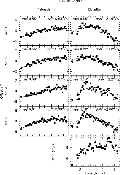
Figure 5: October 1st data. The wind direction was almost exactly North; The antennas were pointed to the South-West at 40-60 degrees elevation.