JUNE 1996
Released September 1998INVEREX Ltda. Paseo Bulnes 139, Oficina 46, Santiago. Teléfonos: 6723881 - 6717111. Fax: 6965594
This report is focused on a preliminary evaluation of: (1) possible sources of water supply and (2) any obvious geological evidence regarding the quality of the basement which would preclude the construction of the facility for the Millimeter Array Radio Telescope, a project proposed to the National Science Foundation by the National Radio Astronomy Observatory.
The main points to consider are:
(1) The operating phase of the Project should involve approximately 5-7 persons at the site. This would roughly require 1.4 cubic meter of fresh water per day (less than 0.1 liter/second), based on an estimated water consumption of about 200 liter per person per day (high standard daily consumption).
(2) The facility has to be built on a stable site able to support the weight of the 8 meter antennas that will be spread over an area of 3 k.
To develop this study, a field visit took place on May 1-2 and another on May 22-23,in which a geological observation and search for water supply were conducted.
The regional geological information was gathered from geological literature published by the Servicio Nacional de Geología y Minería (equivalent to the U.S. Geological Survey), in a 250.000 scale map.
The hydrological information was obtained from data published by the Dirección General de Aguas, Ministerio de Obras Públicas de Chile (General Water Resources, Ministry of Public Works).
The topographic information was provided by 1: 50.000 scale maps published by Instituto Geográfico Militar de Chile (Geographical Institute, Chilean Army), and aerial photograph scale 1: 50.000 provided by the Servicio Aerofotogramétrico de la Fuerza Aérea de Chile.
The information about water rights was taken from the last two years of the Official Issue (Diario Oficial de Chile), where all water rights applications have to be published.
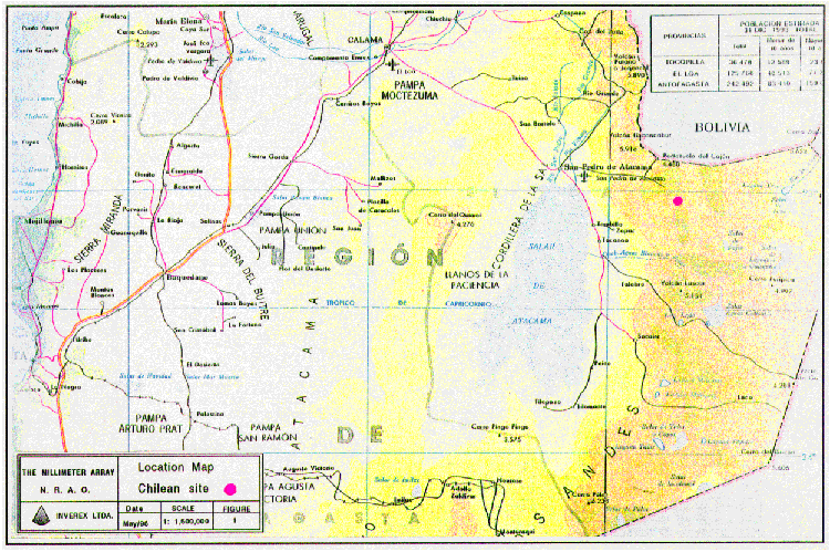
The Salar de Atacama proposed site is at 5.000 m (16.400 ft) in the mountains that conform the East border of the Salar de Atacama basin, II Region, Chile (Figure 1).
The proposed location is about 380 km East of Antofagasta city, harbour and Region Capital, 160 km East of the city of Calama, and 50 km East of the San Pedro de Atacama town.
The access is by a paved road in good to regular condition from Antofagasta to San Pedro de Atacama. From San Pedro de Atacama up to approximately 10 km from the site is an international unpaved road under construction. This road should be improved and continuously maintained to allow the traffic to Bolivia. The last 10 km segment is currently abandoned and requires a four wheel drive vehicle to access the site. The road condition could be critical after next winter.
In general, the access to the site should be difficult during the winter season, June to September due to the snow, and sometimes during the called Bolivian Winter, January and February due to very heavy storms.
The best way to get to the site from Santiago is by plane, in a regular airline which takes 2 hours to Calama, and 3 hours more from there in a four wheel-drive vehicle.
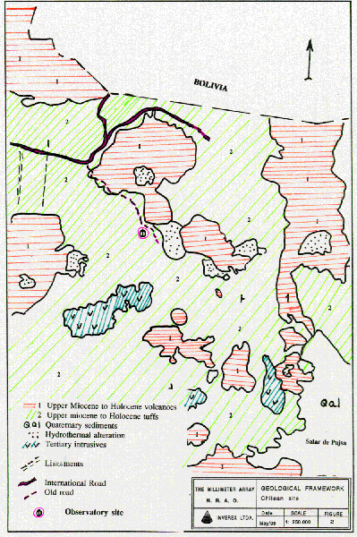
The proposed site is within a volcanic region, with activity in Quaternary times, with ages ranging from 0.7 to 1.7 million years ago (Figure 2). The volcanic activity developed the highest relief of the area; a tuff and an ignimbrite cover defines a straight slope towards the low altitude areas.
The site itself is over an ignimbrite, called Ignimbrita Cajón (Quaternary), and characterized by light pink tuffs outcrops. These outcrops form a flat relieff, following the topographic slope. These rocks are usually below a thin intemperized cover that increases its thickness downwards.
In the overall region there are regional geological structures: lineaments and normal faults. These structures are oriented mainly North-South, and have been studied at 1: 250.000 scale. However, in the area of the site itself these types of structures are not visible.
The quality of the normal ignimbrites outcroping in the area allow to built a road for heavy trucks with a normal gravel-shale basement.
There are no evidences of mass wasting processes that could affect the site.
The site is bounded by the Salar de Atacama basin on the West and the Salar de Pujsa the East. Both are closed basins with minimum elevations of 2.500 meters in the former, and 4.500 meters in the latter.
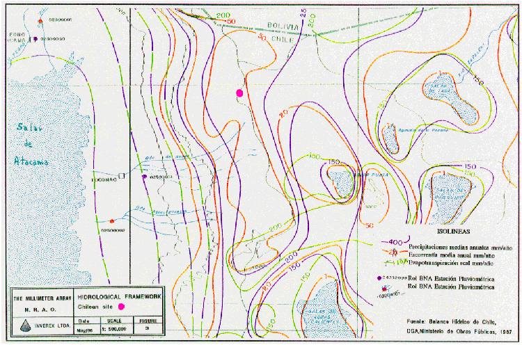
There are some pluviometrics and fluviometrics stations with data for some years, located at the Eastern side of the Salar de Atacama, which allows the assessment of the general hydrological conditions of the area.
The stations are located as shown in Figure 3, and they provide the information to draw the countours on average precipitation.
The yearly average precipitation over the site is slightly more than 250 mm, with the largest activity in January-February.
The site is located in a divisory hydrological basin line, with no surface water flows.
The drainage system in the Ignimbrita Cajon is absolutely dominated by the topographic slope, forming subparallel forms oriented towards the Western or Eastern topographic basins. The volcanic buildings have a drainage related to the topographic relief without any structural control.
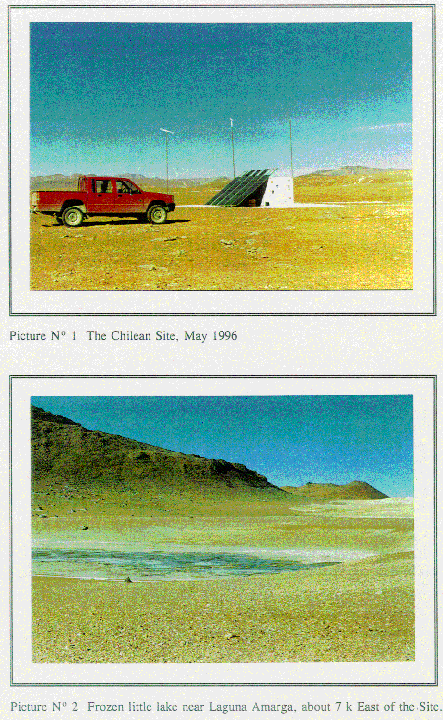
There are no permanent surface water flow nearby the site (Picture 1). However, there is a small lake (Laguna Amarga) about 6 to 7 km from the site which was frozen at the time of the visit (Picture 2). The quality of this water is unknown, but it is probably not good to drink.
The daily average temperature for a small town called Socaire, 50 km South-West of the site and at only 3,251 m of altitude, is 10.5 °C. At the site, the probable temperature during the night is below freezing almost the year round.
The site is almost directly over the volcanic tuff belonging to the Ignimbrita Cajon. These rocks are capable to develope an aquifer with a high potential of underground water supply, as in other areas of the Northern Altiplano of Chile. However, in this case, because it is located on an hydrological basin border, this potential is strongly reduced. The Ignimbrita Cajon, however, could be the recent hydrological basin border, where an underground water communication between the two basins could exist below the Ignimbrita Cajon.
At the old volcanoes, the water infiltration from rain and snow begins from the higher elevations, so there are water spring systems in some drainages located at lower altitudes.
At the date of the first field trip, it was detected one of this water springs at the Northern flank of the Purico elevation. This water spring could provide almost 0.5 liter/second the year round. This flow remains at the surface for some meters an then infiltrate to the underground. This spring is approximately 10 km from the site, and probably frozen most of the year.
By verbal comunnication from Mss. Moyra Gardeweg, Geologist, we know that the surface water nearby the site has bad quality. In fact, in her geologist field work in the same area she had to bring water from San Pedro de Atacama.
The visit of the area allowed to determine that there are no constructions to provide water to any person or company, thus we conclude that there are no water rights awarded in old times.
Since the exploration concessions expire after two years, the Chilean Official Issue was revised during this period and no application over the site was found.
The information obtained allowed us to conclude that in the area of the project there are no known water rights concession or water exploration rights. This is a very normal situation because there is no interesting underground water potential in the area that could be of interest to mining companies, and there are almost no human activities that could demand the resource.
The visible potential resource is associated to the water springs, and the Laguna Amarga little lake, and their rights seem to be free at this moment.
To make an application over these rights it is necessary to demonstrate that the springs or the Laguna Amarga are not related to the called "bofadales," a unique biological system of the highs altitude northern areas, and to demonstrate that they have the volume of flow that the applicant is requesting.
With the information described above, it is possible to arrive to the following conclusions:
The site, located at 5.000 m (16.400 ft) in the border of two hydrological basins, has no surface water flow and a low potential of underground water.
Around the site, there are some water springs and a pond called Laguna Amarga. Both sources are more than 7-8 km of the site, and the water quality is unknown but probably bad in both sources.
The project will demand an estimated water flow less than 0.1 liter/second.
The site is located on an flat and soft tuff-ignimbrite cover that allowed the construction of a road for heavy trucks, therefore it is strong enough for building the facilities for the Project.
There are no visible geological risks conditions associated with the construction of the astronomical facilities.
The water supply for the project could originate from the following sources:
Water from springs and Laguna Amarga
Depending on water quality of these sources, they could provide some time of the year water for the Project. This solution would demand the construction of a pipeline with more than 5 km, of a very small diameter, and some minor work at the source itself. The construction of the pipeline has to consider that the temperature outside could reach several degree Celsius below zero, so it has to be protected against freezing. It is very likely that these springs are frozen during the winter.
The cost of bringing water from a spring could amount to US $30,000. However, there is not a good solution specially because the possibility that the sources might freeze for long time during the year.
Water from San Pedro de Atacama.
It is possible to supply the water from San Pedro de Atacama by truck. One truck per week should be enough, because the estimated water consumption is low. During winter season, however, the supply will depend on the road condition (the international road is not intended to be open the year round).
This is the least expensive option, probably US$ 1,000 per month.
Water from underground the site of the project.
In spite of a low potential of underground water in the site, it could be reasonable to conduct an exploratory campaign to define this potential. The hydrogeological hypothesis is that both basins could be communicated by permeable rocks below the ignimbrites.
To prove that, it is necessary to drill an exploratory well in the area where we think the basement rock below the ignimbrite cover is deepest. To find this place, it will be necessary to conduct a gravimetric survey over the site.
The advantages finding underground water on the site are:
(1) that there is no freezing problem, because the underground water temperature is always above freezing temperature (due to the high thermal gradient in the region), and (2) in general, the underground water quality is very good.
The cost of this option depends on both, the exploration phase and, been successfully, the facility itself. The cost of the gravimetric study and the drilling of an exploratory well up to 100 meters (328 ft) should be about US$ 15,000-25,000, and would allow us to define the availability of water and its quality. If the results are positive, the definitive facility should cost about US$ 40,000-60,000 (all the figures are very rough).
Independent of these options, the site has to have a water tank big enough to provide several weeks of water consumption.
c) Quality of the rock basement at the site.
The proposed site is over soft volcanic rocks, tuff an ignimbrites, that allows the construction of roads for heavy trucks. At the same time, there are no evidences of geological conditions that could define any risk for building facilities at the site. Preliminary, it seems feasible to flat an area and build the radio astronomical array.
Regarding water supply, we recommend to get the water from San Pedro de Atacama and trucking it to the site. The quality of the water will be the same that the Project Office and accommodations at San Pedro could get.
If the Project demands an on-site supply, it is possible to explore the site for underground water. Even though possibilities of a successful outcome seem high, it is not possible to ascertain without further exploration. If this option is considered, it is required to make an application for water exploration rights at the site in advance.
Regarding the facility location, it seems that the site provides a stable ground for building good foundations and there are no evident geological risk that preclude its construction.
Francisco Townsend G. Geologist
June, 1996.
Marinovic, N., Lahsen, A., 1984. Sevicio Nacional de Geologia y Mineria. Hoja Calama, 1: 250.000 scale.
Ramirez, C., Gardeweg, M., 1982. Sevicio Nacional de Geologia y Mineria.Hoja Toconao, 1: 250.000 scale.
Dirección General de Aguas, Ministerio de Obras P0blicas, 1987. Balance Hidrico de Chile.
N° 1.- General location.
N° 2.Geological framework.
N° 3.Hidrological framework.
N° 1.- Chilean Site, May/96
N° 2.- Frozen little lake, Laguna Amarga area.