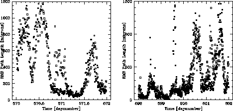
Figure 1: Example time series of the phase stability above the Chajnantor site (solid boxes) and Pamba la Bola site (open boxes). Time is measured in days since Jan 1 1995, Chilean local time.
M.A. Holdaway
National Radio Astronomy Observatory
949 N. Cherry Ave.
Tucson, AZ 85721-0655
Satoki Matsushita, M. Saito
Nobeyama Radio Observatory
Minamimaki, Minamisaku Nagano 384-13, Japan
July 1, 1997
We present a preliminary comparison of seven weeks of phase stability site testing data from the Pampa la Bola and Chajnantor sites, which are separated by only about 8 km. The comparison indicates that the overall distribution of rms phase errors is similar for the two sites (the median rms phase error is about 17% higher at Pampa la Bola). However, at any given time the rms phase on the site testing interferometers' 300 m baselines may be very different at the two sites, sometimes by as much as a factor of 10 different. Presumably, the frequent significant difference in the two site's rms phase is due to the effects of the local topography on turbulence. Being 5 km downwind from a mountain which is 600-800 m higher than the site results in an increase of about 20-30% in the rms phase, and increases the thickness and scale of the turbulence. Both these trends are very noisy, so chaotic local effects play a large role as well.
The wide range of phase stability seen at the two sites at the same time has implications for observing and phase monitoring for the MMA's 3 km array, the LMSA's 2 km array, and the 10 km Atacama Array, as there will frequently be times when the phase stability varies greatly over the array.
Phase stability is known to depend upon the local environment of a site, and it is now standard protocol to deploy a phase monitoring interferometer to test new prospective millimeter wavelength astronomical sites which will have large aperture or long baseline telescopes (Ishiguro, 1990; Mason, 1994; Radford, et al. 1996).
The NRAO has been monitoring the phase stability of the Chajnantor site in northern Chile by observing a 11.2 GHz satellite beacon with a 300 m baseline interferometer since May 1995. The NRO became interested in the adjacent Pampa la Bola site, but various parties expressed concern over the phase stability being adversely affected by the local terrain of the Pampa la Bola site. The Pampa la Bola site testing equipment is located 4.5 km east-northeast of the 5700 m Cerro Chajnantor, which could produce a turbulent wake on the downwind Pampa la Bola side. NRO has been monitoring the phase stability at the Pampa la Bola site with equipment almost identical to NRAO's starting in July 1996, but instrumental failures wiped out late 1996. The interferometers were working at both sites for a period of about 7 weeks between July 23 1996 and September 9 1996, which constitutes one of the periods of better than average phase stability.
The Chajnantor site displays strong diurnal variation in the phase stability (though not as strong as on Mauna Kea), and a fairly strong seasonal variation in the phase stability. Hence, it is critical that any comparison of the two sites sample the phase stability at the same times. We have created a database which includes data only when both instruments produced reliable phase stability measurements within 5 minutes of each other.
The simplest comparison between the two sites is to look at the rms phase over several crossing times of the interferometer (10 minutes) after a quadratic trend has been removed from the data to account for satellite motion and thermal drifts (Holdaway et al., 1995). Figure 1 compares the rms phase time series for the two sites for a two day and a four day period. During most of day 570, the two sites have very similar rms phases which track each other up and down. However, right at dat 571.0, the rms phase is very low at Chajnantor but is quite high at Pampa la Bola. Conversely, there are features in the rms phase which mainly affect the Chajnantor site, or affect the Chajnantor site worse, at day 598.4, 599.5, 600.4, and 601.5.
Figure 1: Example time series of the phase stability above the
Chajnantor site (solid boxes) and Pamba la Bola site (open boxes).
Time is measured in days
since Jan 1 1995, Chilean local time.
Figure 2 further demonstrates the difference of the
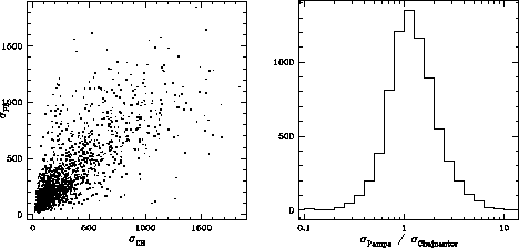
Figure 2: Scatter plot of ![]() as a function of
as a function of ![]() and histogram of
and histogram of ![]() .
.
phase stability above the two sites. Quite often, the two sites track
each other, but the rms phase can be quite different, as much as a
factor of 10, on the two sites. In spite of the differences in the
detailed time series of the two sites, the cumulative distributions of
the rms phase for the two sites is very similar (see
Figure 3). The median rms path length was 183 ![]() above Chajnantor and 215
above Chajnantor and 215 ![]() above Pamba la Bola (a 17%
difference).
above Pamba la Bola (a 17%
difference).
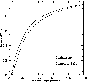
Figure 3: Cumulative distribution of the phase stability above the two sites.
This situation is nearly identical to what was discovered in the phase unpublished stability comparison between the Mauna Kea VLBA site and the Mauna Kea summit: the minute by minute rms phases at the two nearby sites sometimes track each other closely, but sometimes can be extremely different. Nonetheless, the cumulative distributions of rms phase are very similar, implying that the nearby sites are heavily influenced by local turbulent effects caused by the local site topography. On Mauna Kea, the local topography was the Mauna Kea summit (the two sites were essentially on opposite sides of the summit). At Chajnantor, the local topography consists of Chajnantor mountain which is west of the NRO site and north of the NRAO site, and Chascon mountain, which is east of the NRAO site and south of the NRO site. When the wind blows from the north or east, the NRAO Chajnantor site is in the wind shadow of the mountains, and phase stability should be poorer there than at Pampa la Bola. When the wind blows from the south or west, the NRO Pampa la Bola site will be in the wind shadow of the mountains, and phase stability should be poorer at Pampa la Bola than at Chajnantor.
All wind directions are not created equal, however. Winds from the east bring moist air from the Amazon basin over the site (known as the Bolivian Winter, even though it occurs in the southern hemisphere summer), degrading phase stability and opacity. During the winter months when the opacity and phase stability are best, the wind comes almost exclusively out of the west. Therefore, we compare the ratio of the rms phase of the two sites with the wind direction. We only have access to weather measurements at the Chajnantor site. The wind direction near the surface will not always be indicative of the winds aloft, so we expect this to add some noise into the comparison. Indeed, Figure 4 shows a lot
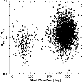
Figure 4: Semilog scatter plot of ![]() as a function
of wind direction (north = 0
as a function
of wind direction (north = 0![]() , east = 90
, east = 90![]() ).
When the wind comes from a direction between 0-180
).
When the wind comes from a direction between 0-180![]() ,
the median
,
the median ![]() is 0.75. From other directions,
the median
is 0.75. From other directions,
the median ![]() is 1.22.
is 1.22.
of scatter when the ratio of the rms path lengths at Pamba la Bola and
Chajnantor is plotted against wind direction. However, as predicted,
the site which is downwind from one of the mountains has higher rms
phase than the site which is not downwind from one of the mountains.
For example, when the wind is cominging from between 0![]() (north) and 180
(north) and 180![]() (east-southeast), the Chajnantor site is
downwind from one or other of the mountains and the median value of
(east-southeast), the Chajnantor site is
downwind from one or other of the mountains and the median value of
![]() is 0.75. For the other wind directions,
the Pampa la Bolla site is downwind of the mountains and the average
value of
is 0.75. For the other wind directions,
the Pampa la Bolla site is downwind of the mountains and the average
value of ![]() is 1.22. Being about 5 km
downwind from a mountain which is 600-800 m higher than the site
elevation seems to increase the rms phase by about 20-30%, on
average. Since the wind is almost always blowing out of the west,
Pampa la Bola is usually the downwind site. However, the large amount
of scatter in Figure 4 implies that more
complicated local turbulent effects also occur.
is 1.22. Being about 5 km
downwind from a mountain which is 600-800 m higher than the site
elevation seems to increase the rms phase by about 20-30%, on
average. Since the wind is almost always blowing out of the west,
Pampa la Bola is usually the downwind site. However, the large amount
of scatter in Figure 4 implies that more
complicated local turbulent effects also occur.
We can explore this hypothesis further. If the mountains are
injecting turbulence, we would expect the scale and thickness of the
turbulent layer to increase. The phase structure function power law
exponent ![]() (where
(where ![]() is defined through
is defined through ![]() ,
, ![]() being the baseline length and
being the baseline length and ![]() being the rms phase) provides evidence for the thickness of the
turbulent layer. For turbulent layers much thinner than the baseline
length, we expect
being the rms phase) provides evidence for the thickness of the
turbulent layer. For turbulent layers much thinner than the baseline
length, we expect ![]() to be about 0.33, and for turbulent layers
much thicker than the baseline length, we expect
to be about 0.33, and for turbulent layers
much thicker than the baseline length, we expect ![]() to be about
0.83. Intermediate values of
to be about
0.83. Intermediate values of ![]() can be obtained with
intermediate thicknesses, or with a mixture of thin and thick layers.
In Figure 5, we plot the ratio of
can be obtained with
intermediate thicknesses, or with a mixture of thin and thick layers.
In Figure 5, we plot the ratio of
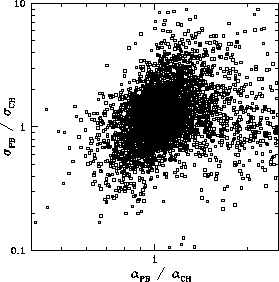
Figure 5: Log-log scatter plot of ![]() as a function
of
as a function
of ![]() (where
(where ![]() is the power law power
of the root structure function). Since larger
is the power law power
of the root structure function). Since larger ![]() indicates
a thicker turbulent layer, the general trend in this plot implies that
the rms phase increases with the thickness of the turbulent layer. The
Pampa la Bola site tends to have a thicker turbulent layer than than
the Chajnantor site.
indicates
a thicker turbulent layer, the general trend in this plot implies that
the rms phase increases with the thickness of the turbulent layer. The
Pampa la Bola site tends to have a thicker turbulent layer than than
the Chajnantor site.
the rms phase against the ratio of the ![]() 's at the two sites.
Again, the plot has a lot of scatter, but when a site has larger
's at the two sites.
Again, the plot has a lot of scatter, but when a site has larger
![]() (ie, a thicker turbulent layer) it tends to have larger
rms phase fluctuations, relative to the other site.
The trend in the data (at least when
(ie, a thicker turbulent layer) it tends to have larger
rms phase fluctuations, relative to the other site.
The trend in the data (at least when ![]() ,
is
,
is
![]()
We do not see any relationship between ![]() and the temperature, the surface wind speed at the Chajnantor site, or
the wind speed aloft at either site. The wind speed aloft at the two
sites shows a broad, noisy correlation similar to the rms phase.
and the temperature, the surface wind speed at the Chajnantor site, or
the wind speed aloft at either site. The wind speed aloft at the two
sites shows a broad, noisy correlation similar to the rms phase.
References
Holdaway, M.A., Radford, Simon J.E., Owen, F.N., and Foster,
Scott M., 1995, MMA Memo 129, ``Data Processing for Site Test
Interferometers''.
Ishiguro, M., Kanzawa, T., and Kasuga, T., 1990, ``Monitoring of
Atmospheric Phase Fluctuations Using Heostationary Satellite
signals'', in Radio Astronomical Seeing, eds. Baldwin and
Shouguan.
Masson, C.R., 1994, ``Atmospheric Effects and Calibration'', in
Astronomy with Millimeter and Submillimeter Wave Interferometry,
eds. Ishiguro and Welch.
Radford, S. J. E., Reiland, G., Shillue, B., 1996, ``Site Test
Interferometer'', PASP 108, 441.