M. A. Holdaway, M. A. Gordon, and S.M. Foster
National Radio Astronomy Observatory
949 N. Cherry Ave.
Tucson, AZ 85721-0655
F. R. Schwab
National Radio Astronomy Observatory
520 Edgemont Rd
Charlottesville, VA 22903-2475
Hernán Bustos
Cerro Tololo Inter-American Observatory
Calle Mariatequi 2438
Providencia
Santiago 1, Chile
email: (mholdawa, mgordon, sfoster, fschwab)@nrao.edu
Aug 28, 1996
This memorandum presents new digital elevation models (DEMs) of the candidate sites for the Millimeter Wave Array (MMA) and the Large Millimeter and Submillimeter Arrays (LMSA) in Chile with a planar resolution of 5m. Made by McLain Aerial in Tucson from aerial photographs provided by the Instituto Geographico Militar de Chile, these DEMs will facilitate tentative layouts of the antenna configurations, roads, and support buildings for both telescopes.
Digital Elevation Models (DEMs) are available at about 30 m resolution for much of the United States through the United State Geological Survey. In order to plan the MMA configurations, Ge (1992) obtained DEMs for the South Baldy and Springerville areas, and Holdaway (1994) obtained a DEM for Mauna Kea. The DEMs are easily converted into FITS images that can be displayed and manipulated with our existing astronomical software. Various software tools have also been developed to aid in the placement of antennas on these DEM grids.
We have not been able to locate high resolution DEMs for our site in northern Chile. However, in 1981-82 the Instituto Geografico Militar de Chile surveyed the entire country with high quality, high altitude aerial photographs with a 60% overlap. Photogrammetry can make a stereographic image of the earth's surface in the overlapping region of the photographs. McLain Aerial in Tucson has performed this work for us.
The ground resolution depends upon the angular resolution of the photography and the altitude above the site at which the plane was flown. Our maps have an intrinsic horizontal resolution of about 5 m (the vertical resolution being somewhat better). In order to make maps with an accuracy comparable to the theoretical resolution, some amount of ``ground control'' is required at the time the photographs are taken. Ground control usually consists of several objects on the ground with accurately surveyed positions that show up easily in the aerial photographs (usually large white crosses you sometimes see lying on the ground in areas of impending development). When enough such objects are present in each photograph (typically four), uncertainties in the position and orientation of the camera at the times the photos were taken can be determined, allowing accurate positions and elevations of ground features.
Although precise ground control was not available for the MMA and the LMSA candidate sites, McLain Aerial iterated from the positions of easily identifiable features on the large-scale contour maps of the region produced by the Chilean government. These maps have a scale of 50,000:1 with 50 m contour intervals in Universal Transverse Mercator (UTM) coordinates referenced to the Venezuela 1956 geodetic datum (often referred to as the South America 1956 or SAM 56 datum). The South America 1969 geodetic datum (SAM 69) is the current standard in Chile, but we could not obtain contour maps of the area referenced to SAM 69. At the Chajnantor site, the SAM 56 and SAM 69 UTM coordinate grids are offset by about 300 m. It would have been possible to reference the new DEMs to SAM69, but we preferred to be able to compare our DEMs to the existing 50,000:1 contour maps in the SAM 56 datum. Hence, our new contour maps and DEMs are in UTM referenced to the SAM 56 map datum. This is not a problem since our GPS receivers can calculate SAM 56 UTM coordinates. If the SAM 56 UTM coordinates become a problem in the future, we can perform a geometrical transformation of the digital elevation models to reference them to SAM 69.
The a postiori ground control points and resulting camera positions and orientations were self-consistent to a high degree, so the dominant residual errors due to the lack of a priori ground control are gross positional offsets or elevation gradients across the map. The relative accuracy of the map features is expected to be close to the theoretical resolution of 5 m. At this stage, our primary use for this topographical map is to determine acceptable relative locations for antennas, for which the current map is well suited. More detailed survey work should be performed in the future at each antenna station location and at the site of any buildings.
The fundamental data product given to us by McLain Aerial consists of a file of ``break lines'', vectors of (x,y,z) values which trace ridges or valleys. Interpolation between two adjacent break lines works, but extrapolation outside a pair of break lines clearly does not make sense. A region which has not been adequately sampled in its break lines will neither have the horizontal resolution nor the vertical accuracy which is theoretically possible. Since we are not primarily interested in the mountains around the sites, the level of attention given to the mountain break lines is not commensurate to that of the open plains, which is why the mountains appear a bit boxy (see Figure 3, for example). However, the mountain ridges will have enough accuracy to determine their shadowing of astronomical sources as viewed from the plain to about a degree on the sky.
Two classes of secondary data products were generated from the break lines: contour maps, and DEMs on a 10 m grid. The DEMs have been converted into FITS format so that it can be displayed and manipulated with our astronomical software. From the DEM we can recontour the image with any contours we chose, display subregions, and derive various site properties such as topographical slope or shadowing. The DEM and software to manipulate it are very important tools for designing an astronomical array and its supporting infrastructure.
Figure 1 shows a 20 m contour map of the Chajnantor site
together with the Pampa la Bolla site which is being tested by NRO.
Figure 2 shows the inner ![]() 5 km section of the
Chajnantor DEM with 5 m contours. Figure 3 shows a
three dimensional rendering of the Chajnantor site's surface as seen
from above, and Figure 4 shows a three dimensional
rendering from an oblique view. The web site
http://www.mma.nrao.edu/sites/Chiledems.html shows three
dimensional rendering of the Chajnantor site's surface in color.
5 km section of the
Chajnantor DEM with 5 m contours. Figure 3 shows a
three dimensional rendering of the Chajnantor site's surface as seen
from above, and Figure 4 shows a three dimensional
rendering from an oblique view. The web site
http://www.mma.nrao.edu/sites/Chiledems.html shows three
dimensional rendering of the Chajnantor site's surface in color.
Visitors to the site have recognized that the drainages which cross the Chajnantor site will need to be considered when planning the antenna locations of the 3 km A configuration. The B, C, and D arrays are small enough that the topography need to affect the detailed placement of the antennas, but we must pay attention to the drainages when selecting the placement of these smaller arrays on the site.
References
Ge, Jing Ping, 1992, ``Further Simulations of (Possible) MMA
Configurations'', MMA Memo 80.
Holdaway. M.A., 1994, ``Preliminary MMA Configurations for Mauna Kea'',
MMA Memo 111.
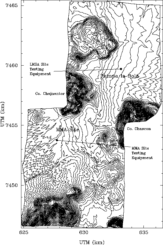
Figure 1: Contour map of the Chajnantor and Pampa la Bola sites with
20 m contours.
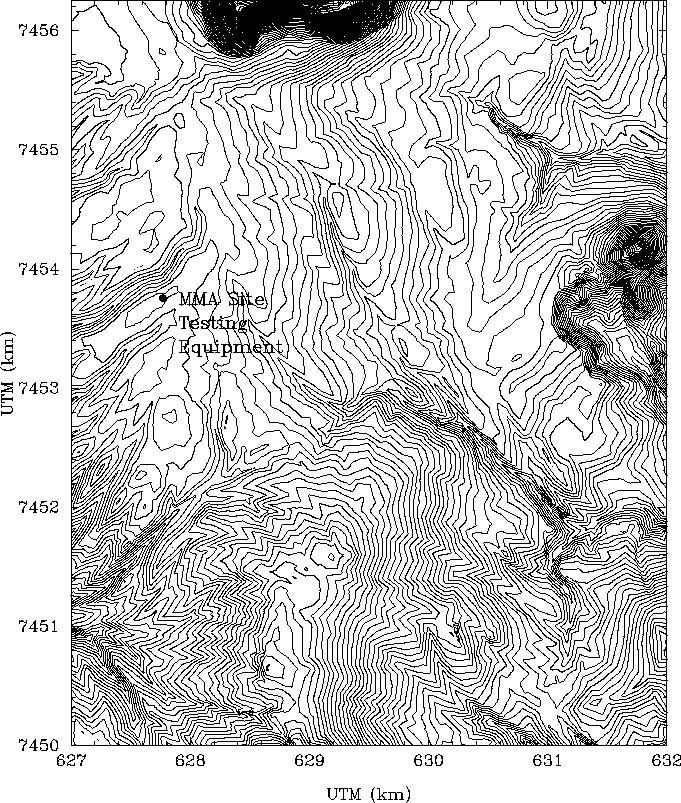
Figure 2: The inner ![]() 5 km of the digital elevation model
for the MMA site with 5 m contours.
5 km of the digital elevation model
for the MMA site with 5 m contours.
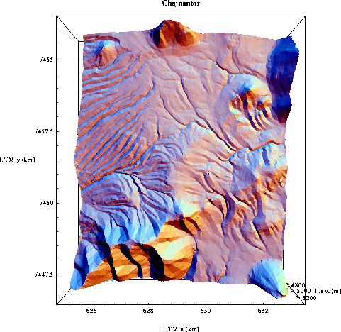
Figure 3: Three dimensional view of the Chajnantor site from overhead.
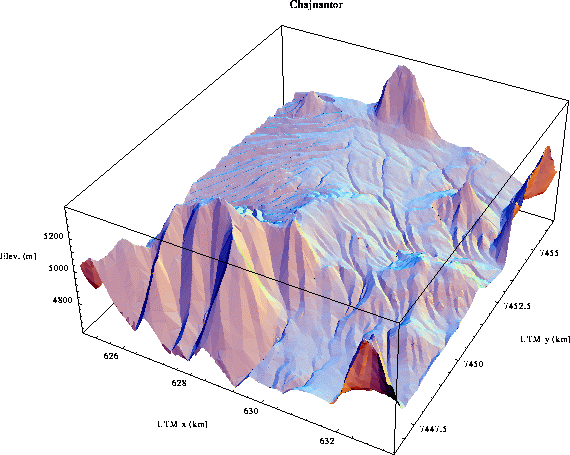
Figure 4: Three dimensional view of the Chajnantor site, oblique view.